


It's been a while since we posted anything (almost a year!), and we need to catch up. We just took a trip up to the Mt. St. Helens area (Coldwater Lake) and had a great hike. We also went up to Olympia for the night, then onto Enumclaw, WA for the Enumclaw Highland Games, but those will be in another post. This post will be about the Coldwater Ridge hike on 30-Jul-2011.
The start of the trail (below) let us know that we were going to see lots of wildflowers on this hike. Even the trail head was covered with lupine and other wildflowers.

The hike was almost a constant steady climb, with almost no dips from 2500 ft up to 3800 ft.. The first part is up a sparsely treed hill, with even more wildflowers. Most of the yellow flowers below are just dandelions.

We began to see lots of small trees with absolutely no leaves left, and they were covered with webs full of caterpillars. In this lower section of the hike, almost all of the trees were stripped of their leaves.

The caterpillars were even building their webs in the ground plants, like the lupines and grasses.

They were everywhere! You couldn't walk without crunching a dozen or more. They were climbing up every plant, stump, or tree looking for leaves to eat. The only thing we didn't see them eating was the foxglove. We figure the digitalis in the foxglove was poisonous or noxious to them.

If you were quiet, you could hear them chewing in the woods!

OK, enough about caterpillars! Back to the hike as we continued climbing through little open spots full of daisies, lupine, Indian Paintbrush, foxglove, and more.

As we approached the top of the ridge, we started seeing the stumps of trees that were blown over by the shockwave of the eruption.

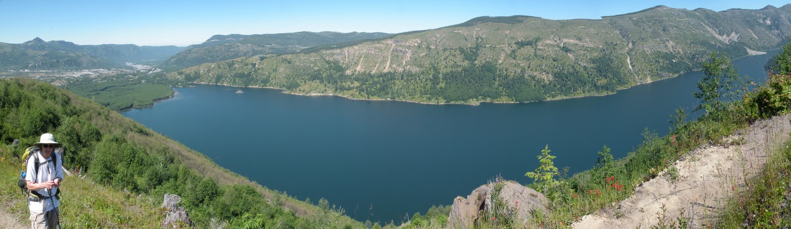
Once you reach the open ridge, you have a great view of Coldwater Lake. Past eruptions of Mt. St. Helens formed this lake. In the picture below, the left side of the lake is where a debris flow blocked a creek. This dam has created the lake. At the end of this blog post, we will show some pictures from the lake itself looking back at the ridge. These pictures were taken from a small boardwalk that you can see (if you click on the picture below and look in the upper left of the lake. It looks like a circular board walk going around a small island).
At the top of Coldwater Ridge, you can see some winches and bulldozers that the geologists were using before the eruption. They are still there, and you can see what the shockwave did to them. In the picture below, you can see where the side of Mt. St. Helens blew away and came towards the tracked winch.

Here are the remains of a bulldozer that was about 200 feet away from the winch.

A side view shows more of the damage to the bulldozer. You can see where the blade stopped some tree roots and debris.

After a little over two hours, it was time for a lunch break. Below, Annie is checking out our lunch spot to see how far the drop is if we fall off. I don't think she knew I was taking this picture.

OK, it's safe to eat on!

After lunch, we had an easy hike back down to the trail head. It was about a 6-mile hike roundtrip. Not far, but enough to make you sore the next day! Once at the bottom, we went around to the dam of the lake to see what the ridge looks like from down below. Here's a shot showing Coldwater Ridge with Mt. St. Helens behind it.


I found this shot of Mt. St. Helens (before the eruption) in an information display. You can see the height of the mountain before.


A little closeup shot that shows where we went. We went around to the other side of the peak in the center of the picture below.

I found this shot of Mt. St. Helens (before the eruption) in an information display. You can see the height of the mountain before.

This shot is from a slightly different point, but you can see how much of the mountain got blown away.


On the way back out, we stopped at various view points to look at the mountain. This picture shows Castle Lake to the bottom right of Mt. St. Helens. It's another lake that a past eruption of the mountain has created.


This is a tired hiker resting her feet!

On the way back out, we stopped at various view points to look at the mountain. This picture shows Castle Lake to the bottom right of Mt. St. Helens. It's another lake that a past eruption of the mountain has created.

Now for the obligatory panorama. This is from Elk Rock view point, and gives a little sense of the scale of the area.


Thanks for checking out the blog. We'll try to be a little more frequent on our postings.