Wednesday, October 28, 2015


Iceland - September 2015


Hello and welcome to our first photo-blog post in a very long time!  Almost two years!  We haven't had a lot of time to do any posts, due to all of the house renovations and other jobs that come along with life.  But we think we have most of the house finally finished (unless we decide to move it 6 inches to the left, or turn it around), so we can enjoy the house for a while and not work on it.

John had earned a sabbatical at work, and we had been planning a trip to France for quite a while.  We found some great ticket prices on Icelandair, and a friend of Annie's told us that if you flew Icelandair, you could get a free stopover in Reykjavik.  That's all it took!  We carved out 3 days from our trip to France and stopped off in Iceland.  The picture above is one of the iconic images of Iceland.  It is the Sun Voyager sculpture and it sits in the Reykjavik harbor, representing the seafaring spirit of Iceland - although all of the European countries who were raided by the Vikings may not have the same warm fuzzy feelings!

Iceland is a pretty small country, population-wise.  About 330,000 people total and 180,000 of those live in Reykjavik, according to our tour bus driver.


One the Icelandair flight, the entertainment system will show certain facts about Iceland, if you leave that channel on.  Things like "It's not surprising that Iceland is the most "wired" country in the world, with 97% of the people having Internet access.  The most surprising thing is that 75% of the people believe in fairies and trolls".  So there are a few opportunities to take pictures with trolls!


Another iconic image of Iceland and Reykjavik - the Hallgrimskirkja - a Lutheran church in Reykjavik.  This was the view out of our Hotel.  It's a gorgeous church, inside and out.  Now for a little trivia - it's even been in a Simpsons episode!


These are pictures from the Simpsons episode "The Saga of Carl", that were hanging in the lobby of our hotel (Hotel Leifur Ericsson).  You can see the Hallgrimskirkja in the upper picture and below shows the view from the Church.  Our hotel is the building on the top right of the lower picture!  Yayyy!  We stayed somewhere somewhat remotely notorious!


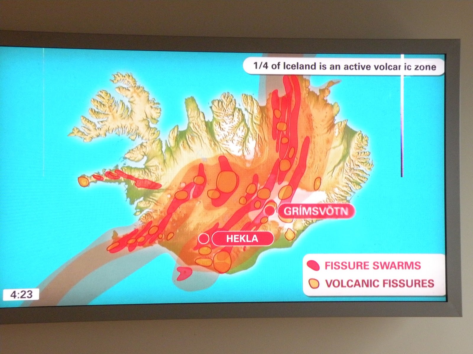
We took a day-long bus tour to do the "Golden Circle".  It's a quick tour around some of the scenic spots near Reykjavik.  First we stopped at a geothermal plant.  The picture above is from a presentation they gave, showing how the mid-Atlantic ridge slices through Iceland, and where the main areas of volcanic activity are.  The Icelanders are the world's foremost geothermal engineers, and they are serving as the design engineers for geothermal plants all over the world.  Almost all of Iceland's energy comes from geothermal and hydropower.


Okay, now for a pop quiz to see how old everyone is and if they can remember way back in the day.  Does anyone remember the James Bond movie "You Only Live Twice" with Sean Connery?  The one where he very badly played an Asian?  In this movie, the bad guys (probably Spectre) had a rocket launch facility underneath a false lake.  When they got ready to launch the rocket, the fake lake top opened up to allow the rockets to launch.  Voila!  Above is the lake that was used for the outdoor shots in the movie. Amazingly, later in the trip while we were in France, the movie came on French TV and we watched to make sure the bus tour guide was right.  And there it was!


This is what you do when you have way too much money, AND you may be experiencing some doubts about your masculinity.  You buy a Mercedes Sprinter van and jack it up 5 feet off the ground.  We saw this at the Strokkur geothermal area.


Here are two different shots of the Strokkur geyser going off.  I put the camera in "action" mode and started squeezing the trigger when I saw the water begin to burst upwards.  In the top shot, the geyser is already about 10 feet high.


About 30 pictures later (and 8 seconds later), the geyser topped out at about 80 feet.


After that, we visited the Gulfoss waterfall.  It's a huge waterfall caused by a glacier-fed river cutting its way down through the lava beds.  It's interesting that it doesn't go straight over the cliffs, but "slides" off to one side and then the other as it works its way downstream.  To get an idea of the size of the water falls, you can see people standing to the left of the top waterfall on the cliffs.


The last stop of the tour was the Thingvellir National Park.  It's a great area, where the mid-Atlantic ridge is on land, and you can see the cracks as the Eurasian tectonic plate is moving east and the North America plate is moving west.  They are spreading apart at about 2 mm (~0.08 inches) per year.


These cracks have been here a long time!  They seem to be pretty stable, and walking paths have been built through them for tourists.  In fact, Icelanders have used these areas for festivals and meetings for over a thousand years.


It was really a great 3 days in Iceland.  We didn't see any northern lights, but you can see from most of our pictures, it was pretty cloudy while we were there.  It would be great to go back, and spend about 10 to 14 days and drive the ring road all the way around the country.  You could then get out and see the active volcanoes, the glaciers, go whale watching - the whole shebang.

That's all for Iceland.  The next post will be on our trip continuing onto France!

John & Annie

Thursday, October 10, 2013

 Hello,

This is our first post in quite a while - maybe a year or two!  Our apologies, but house renovations and other activities have slowed down the blogging.  However, we just got back from a neat little trip into eastern Washington, and we wanted to share some photos with you.

The origin of the trip was to go see the areas of eastern Washington that were impacted by the Missoula Floods about 18000 years ago.  If you would like to learn more about these floods, you can visit Wikipedia at http://en.wikipedia.org/wiki/Missoula_Floods.  For the short version, towards the end of the last ice age, a glacier blocked the Clark Fork River in northern Idaho, which caused a large lake to form in Montana, flooding the area where Missoula is today.  Then every 50 to 70 years or so, the lake would get deep enough to "float" or break through the ice dam and a huge roaring flood would race out of the lake, across northern Idaho, across eastern Washington, and down the Columbia Gorge.  It is estimated that the amount of water flowing across this area was 10X the combined flow of all of the rivers in the world today.

We also decided to add some hiking detours and some touristy stuff.  We left Portland on Sunday, Sept 29th and traveled to Yakima, WA on the first day.  We were going to come back to Yakima later in the trip to do some wine touring, so we didn't spend any time there on this part of the trip.  On Monday, we got up and drove up to the little town of Leavenworth, WA.  It's a small town that has decided to remake itself in the fashion of an Austrian Alps town.  We arrived just as Oktoberfest was going on, but it is much slower during the week than on weekends.

We rented a house outside of Leavenworth in Icicle Gorge.  The first day, we drove up to Lake Wenatchee and did some hiking around it. There was not a lot of good hiking around the lake itself as there are many homes on the lake.  We did find a nice trail on the south side of Lake Wenatchee up to Hidden Lake.

Lake Wenatchee

The next day (Wednesday), we did a hike up Icicle Gorge in a very light rain.  Some friends told us later that the remnants of Typhoon Atlas were hitting the Pacific NW at this time, but we never knew it.  Our house didn't have any TV, so we were unaware of what was happening.  The Icicle Gorge hike was beautiful.  There were all types of wild mushrooms.  We'll include a couple of pictures (out of the hundreds we took).  The first one below is about 18" across!  There were lots of this type growing throughout the Gorge.


We talked to another hiker who said that we really missed the big mushroom show.  He said that the previous weekend was the big show, and there were many more mushrooms and about 10X the variety.  We were pretty impressed with what we saw, so no complaints from us.

We also found a place on the Icicle Creek where someone had set up tons of balanced rocks.


Check this out!


On Thursday, we left Leavenworth and drove up to the Grand Coulee area.  We stopped and checked out the Moses Coulee, where the first Missoula Floods came down before it was cut off by the advancing Okanagan Glacier.  The later floods were directed down the Grand Coulee.  The panorama shot below is the Dry Falls State Park. When the area was in flood, it was the equivalent of 5 Niagara Falls.


We had rented a house on Banks Lake (a huge lake used for recreation and irrigation).  We visited Steamboat Rock State Park, which is a huge mesa still standing after the floods.  It was a great place for Angus to hike and swim!


Pine tree growing on rock!
We had two great days in the Grand Coulee area.  We saw some kitschy stuff, like the Windmill Farm.


And we saw some super impressive stuff, like the Grand Coulee Dam.  This is an amazing accomplishment.  Behind the dam is Lake Roosevelt, which is 151 miles long and goes all the way to the Canadian border.  


We left Grand Coulee and headed back to Yakima, and spent a day touring the Wine country around Zillah, WA.  It was beautiful, and we bought way too much wine.  We had a great picnic at the Bonaire vineyard with Bung - the owners' Australian Shepherd who helped Angus eat a lot of treats!


Bung (back) and Angus (front)

We also visited the 2 Mountains and Dineen Vineyards. We bought a Cab Franc at Bonaire, a red blend at 2 Mountains, and the Cab Sauvignon at Dineen. If you are in the area, do yourself a favor and visit Dineen.  It's a very small vineyard, making a few hundred cases a year of Sauvignon Blanc, Cabernet Sauvignon, and some others.    We sampled wines while Angus chased a tennis ball.  You know the vineyard is dog-friendly when they have a Chuck-it and tennis balls ready for the dog!

It was a great trip.  It's difficult to winnow down to just a few pictures for the blog.  Hopefully this gives you some idea of the area.

Sunday, July 31, 2011

Hiking around Mt St. Helens

Hello!


It's been a while since we posted anything (almost a year!), and we need to catch up. We just took a trip up to the Mt. St. Helens area (Coldwater Lake) and had a great hike. We also went up to Olympia for the night, then onto Enumclaw, WA for the Enumclaw Highland Games, but those will be in another post. This post will be about the Coldwater Ridge hike on 30-Jul-2011.


The start of the trail (below) let us know that we were going to see lots of wildflowers on this hike. Even the trail head was covered with lupine and other wildflowers.


The hike was almost a constant steady climb, with almost no dips from 2500 ft up to 3800 ft.. The first part is up a sparsely treed hill, with even more wildflowers. Most of the yellow flowers below are just dandelions.


We began to see lots of small trees with absolutely no leaves left, and they were covered with webs full of caterpillars. In this lower section of the hike, almost all of the trees were stripped of their leaves.


The caterpillars were even building their webs in the ground plants, like the lupines and grasses.


They were everywhere! You couldn't walk without crunching a dozen or more. They were climbing up every plant, stump, or tree looking for leaves to eat. The only thing we didn't see them eating was the foxglove. We figure the digitalis in the foxglove was poisonous or noxious to them.


If you were quiet, you could hear them chewing in the woods!


OK, enough about caterpillars! Back to the hike as we continued climbing through little open spots full of daisies, lupine, Indian Paintbrush, foxglove, and more.


As we approached the top of the ridge, we started seeing the stumps of trees that were blown over by the shockwave of the eruption.


Once you reach the open ridge, you have a great view of Coldwater Lake. Past eruptions of Mt. St. Helens formed this lake. In the picture below, the left side of the lake is where a debris flow blocked a creek. This dam has created the lake. At the end of this blog post, we will show some pictures from the lake itself looking back at the ridge. These pictures were taken from a small boardwalk that you can see (if you click on the picture below and look in the upper left of the lake. It looks like a circular board walk going around a small island).


At the top of Coldwater Ridge, you can see some winches and bulldozers that the geologists were using before the eruption. They are still there, and you can see what the shockwave did to them. In the picture below, you can see where the side of Mt. St. Helens blew away and came towards the tracked winch.


Here are the remains of a bulldozer that was about 200 feet away from the winch.


A side view shows more of the damage to the bulldozer. You can see where the blade stopped some tree roots and debris.


After a little over two hours, it was time for a lunch break. Below, Annie is checking out our lunch spot to see how far the drop is if we fall off. I don't think she knew I was taking this picture.


OK, it's safe to eat on!


After lunch, we had an easy hike back down to the trail head. It was about a 6-mile hike roundtrip. Not far, but enough to make you sore the next day! Once at the bottom, we went around to the dam of the lake to see what the ridge looks like from down below. Here's a shot showing Coldwater Ridge with Mt. St. Helens behind it.


A little closeup shot that shows where we went. We went around to the other side of the peak in the center of the picture below.


I found this shot of Mt. St. Helens (before the eruption) in an information display. You can see the height of the mountain before.


This shot is from a slightly different point, but you can see how much of the mountain got blown away.


This is a tired hiker resting her feet!


On the way back out, we stopped at various view points to look at the mountain. This picture shows Castle Lake to the bottom right of Mt. St. Helens. It's another lake that a past eruption of the mountain has created.


Now for the obligatory panorama. This is from Elk Rock view point, and gives a little sense of the scale of the area.


Thanks for checking out the blog. We'll try to be a little more frequent on our postings.


Wednesday, August 11, 2010

New Pergola is Finished!

Hello and welcome to our photoblog. I am taking a break from our pictures of France to show an update on our progress in the backyard. You may recall that last year we built a fence so that Angus would have a place to safely play. The photo below was taken after we completed the fence (but before we stained it). Believe me, that umbrella did not help much when it was 105 degrees last summer!


So our back patio looked pretty barren, as you can see below. Not much fun sitting out there at all, even with a double rainbow to enjoy. As you can tell, dogs have no sense of aesthetics. Angus is looking away from a tremendous view of a double rainbow. I guess if they can't pee on it, it doesn't interest them!

Over the winter, we spent a lot of time researching what we wanted to do in the backyard, and settled on building a pergola. We did a lot of designing and came up with a pretty good idea. So when Dad visited in May, we began our construction. We had a local company come in and set up the posts (which would have taken us a month - they did it in 2 hours). And after letting the concrete cure for a couple of weeks, we began building.

And we finally finished it a couple of weeks ago! It looks great! The small pieces of lattice at the posts are protecting some clematis plants from our over-enthusiastic dog when he is playing with Eba, his doggie girlfriend a couple of houses away.


We are very please with how it turned out. Until the clematis gets big enough to shade the patio (in 2 to 3 years), we can still open the umbrella under it.


We tried to match the design of the arbor when we built the pergola, so there is a consistency in the backyard. We also planted a jasmine to climb up the arbor.
Below, you can see that we are using brass and bronze welding rods to give the clematis something to climb on as they grow up the posts. We just drill a hole in the post at the lower end, then insert and bend the rod around the post until it goes where we want it to and drill another hole for the top end. The clematis just follow the rods up the post!


So nothing like celebrating the completion of a huge job! We had a neighborly get-together last Saturday evening (Aug 7th), with a fire for marshmallows and some great neighbors. Standing up in the blue shirt is Kathy Christiansen. She and Dan are our neighbors from across the street, and are the souls of hospitality and kindness. On the day we moved into our house, with boxes everywhere inside and 15 inches of snow outside, she came over and brought us a supper to welcome us. Seated to the left is Dave Cameron and his wife Mary Jo is seated to the right behind a post. They are Eba's owners (Eba is the brown dog behind Kathy), and Peter is the man standing beside Dave. He is a relative of Dave and Mary Jo's and is visiting for the Seattle to Canada bike ride that Mary Jo and Dave are going to do this weekend (Aug 12-15).


Kathy made this wonderful cake, called a "Midsummer Night's Dream" cake. It was unbelievably good! It took her two days to make it.


When you cut into it, you can see why! In the middle, there's a frozen layer of citrus "ice" that is so good. And the white icing is ice cream!


Even Dave, who normally doesn't eat dessert, cannot resist!


We are happy to have this job finished. Now it's onto the next backyard project, which is to re-landscape an area on the other side of the house so that we can put in some raised bed gardens this fall. Next year we plan to eat more of our own vegetables!
Thanks for reading and take care,
John & Annie